South Africans can expect cold and wet weather across much of the country over the coming week. An intense low-pressure system is expected to bring widespread showers and thunderstorms across the country.
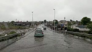
The South African Weather Service warns that the weather system, known as a cut-off low, is notorious for causing flooding, damaging winds and severe thunderstorms.
Schools closures
Western Cape Premier Alan Winde has announced that all schools in the Overberg, Cape Winelands, and Helderberg will be closed on Monday amid warnings of heavy downpours expected for tomorrow.
He says emergency services are on standby. Strong winds continue to lash the province.
Eskom has also announced that it is experiencing a major faults backlog in parts of the Western Cape due to bad weather conditions. Eskom says this could lead to prolonged power interruptions and extended restoration times.
Poor visibility
Meanwhile in KwaZulu-Natal, wet weather and poor visibility along with a crash at Van Reenen Pass are causing congestion on the N3 northbound between Cedara in KZN and Heidelberg in Gauteng.
Two trucks were involved in the crash.
The South African Weather Service has issued a warning following widespread showers and thundershowers across the Free State, Northern Cape and North West provinces.
Forecaster Axinia Sethabela says, “Today we are expecting severe thunderstorms which may lead to heavy rain and hail over the central parts of the country. Provinces such as the Free State, North West, and eastern parts of the Northern Cape would be affected. Strong winds as well as a decrease in temperatures are also expected with temperatures ranging in degrees. The South African Weather Services has issued a warning to drivers and residents to stay alert.”
SA Weather Report | 07 April 2024
Today’s weather rainfall probability and related alerts pic.twitter.com/6S7d2DV9BE
— SA Weather Service (@SAWeatherServic) April 7, 2024
SABC’s Meteorologist Rasimphi Mpho says motorists are being urged to drive carefully.
“Road structures can be damaged because we are talking heavy and persistent rainfall falling in one area for a long time and that will cause flooding. The system also brings strong damaging winds and cold. A cut-off low is actually known to drop temperatures significantly below the 20s and over parts of the country but mostly expecting it over the Western Cape, also moving towards the Eastern Cape, parts of Free State, Gauteng, Limpopo, and Mpumalanga from tomorrow towards Tuesday, temperatures should pick up a little bit and the system will be going southwards.”