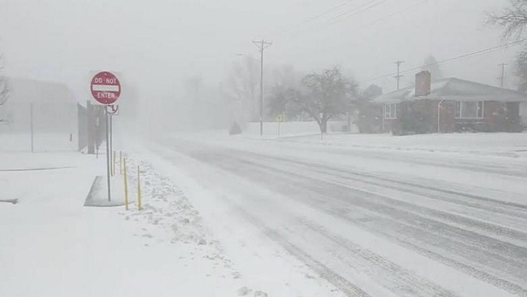
A dangerously frigid arctic air mass gripped a vast expanse of the United States on Thursday ahead of what could be one of the coldest Christmas Days on record, as a looming winter storm threatened to upend travel plans for millions of Americans.
Leading into the holiday weekend, the impending storm was expected to bring blizzard conditions to the Great Lakes region, up to 5 cm of rain followed by a flash freeze on the East Coast, wind gusts of 100 kph and bitter cold as far south as the Mexican border.
As the storm took shape over the Great Lakes on Thursday, a weather phenomenon known as a bomb cyclone was expected to develop from a “rapidly deepening low-pressure” system, the National Weather Service (NWS) said.
The cyclone could spawn snowfalls of 1.25 cm per hour and howling winds gusting to 97 kph from the Upper Midwest to the interior Northeast, producing blizzard conditions and near-zero visibility, the weather service said.
Combined with the arctic cold, wind-chill factors as low as minus 40 degrees Celsius were forecast in the High Plains, the northern Rockies and Great Basin, the NWS said.
Exposure to such conditions without adequate protection can cause frostbite within minutes.
Power outages were likely, and the storm was expected to make travel by land or air precarious or impossible at times.
“It’s dangerous and threatening,” President Joe Biden said at the White House, urging Americans with travel plans to not delay and to set off on Thursday. “This is not like a snow day, when you were a kid, this is serious stuff.”
More than half of the Lower 48 states, from Washington state to Florida, were under winter weather alerts, including wind chill advisories affecting about 135 million people, said Ashton Robinson Cook, a weather service meteorologist.
Parts of the Mid-Atlantic and Plains could see Christmas Day weather that is near the coldest on record, according to the weather service.
The mercury was expected to fall to minus 9 degrees Celsius in Philadelphia on Sunday, near a previous low from 1943, while Sioux City, Iowa, could end up at minus 26 degrees Celsius, surpassing a record from the 1980s.
‘WHITE-OUT’ CHRISTMAS
The storm front could bring more than 30 cm of snow to some areas as it moves eastward out of the Plains and Great Lakes, Cook said.
Snow squalls — brief bursts of moderate to heavy snow and strong wind — were expected from Illinois to Indiana, and could produce white-out conditions.
The American Automobile Association (AAA) estimates 112.7 million people planned to travel 80 km or more from home between December 23 and January 2, up 3.6 million travellers over last year and closing in on pre-pandemic numbers.
More than 3 000 US flights scheduled for Thursday and Friday have been canceled, including nearly 1 000 departures and arrivals at two major airports in Chicago, according to flight-tracking service FlightAware.
“It’s a big deal. They’re ruining Christmas,” Nadia Dickens, 42, a management company worker in Gallatin Tennessee, said on Thursday after Southwest Airlines cancelled her flight from Nashville.
She was headed for Corpus Christi, Texas, for a Christmas Day family gathering where she was looking forward to making tamales with her 94-year-old grandmother.
Dickens managed to book another flight to Austin, Texas, with a relative offering to make the four-hour drive to get her to the family reunion, but added, “I doubt I’ll make it.”
“We’re going to get an inch of snow overnight and the weather is just dreadful all over the place,” she said.
The frigid air mass that had already enveloped northern states was pushing south through central Oklahoma and northwestern Texas, where the mercury was expected to plunge to about minus 7 degrees Celsius on Thursday.
Temperatures in the Southern Plains and Southeast could stay below freezing — but still 30-plus degrees less than normal — for multiple days, the NWS predicted.
Greg Carbin, chief of forecast operations at the Weather Prediction Center in Maryland, said freezing or below-freezing cold is expected to bisect Florida from Pensacola through Orlando to Daytona Beach, with temperatures about 25 degrees below normal.
Motorists in the Ohio and Tennessee valleys were warned that wet roads could instantly freeze over due to a rapid drop in temperatures.
The weather service also warned of freezing rain in parts of Oregon and Washington in the Northwest, where a separate storm was forming on Thursday.
Georgia on Wednesday joined North Carolina and Kentucky in declaring states of emergency.
Temperatures in north Georgia were forecast to hit minus 12 degrees Celsius with subzero wind chills.
“We are expecting weather we haven’t seen in a decade or more,” Georgia Governor Brian Kemp said at a media briefing.
Brandon Mattis, 24, said his flight from New York City to Atlanta was cancelled on Thursday morning because of the coming storm, leaving him “flustered” at La Guardia Airport in Queens. “There was no rescheduling or anything like that,” he said.
Mattis said he searched for alternate routes and was even considering a 21-hour bus ride to Atlanta.
“Anything we can do just to get there, we’re going to do,” he said.