It’s going to be a wet weekend across large parts of the country. The South African Weather Services says thunder showers which could result in localised flooding are expected in parts of the North West, Free State and the Northern Cape.
Free State Today ‘s Weather overview: 29.2.2020 pic.twitter.com/018fpZWDih
— SA Weather Service (@SAWeatherServic) February 29, 2020
North West Today ‘s Weather overview: 29.2.2020 pic.twitter.com/QKe6EASLY3
— SA Weather Service (@SAWeatherServic) February 29, 2020
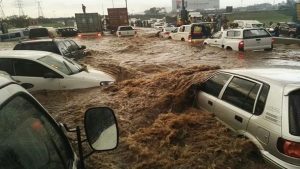
Possible flooding in Gauteng
Emergency services personnel are monitoring low lying areas for possible flooding as the rain continues to fall across Gauteng. The City of Johannesburg says no major incidents were reported across the city overnight.
On Friday a school bus transporting learners was trapped in water in Vundla drive in Soweto and several houses were flooded.
Joburg Emergency Services spokesperson Robert Mulaudzi says: “We are still continuing to monitor low lying areas especially informal settlements. We also want to urge motorists to extend safe following distance. The roads are wet and slippery. And also try and avoid crossing flooded roads and bridges to prevent a situation where the vehicle gets swept away.”
Heavy rain is also predicted for Gauteng and parts of Mpumalanga on Sunday.
Forecaster Wayne Venter says, “We do have saturated ground situation so I would suggest any major thunder storm will result in a possible localised flooding. There’s definitely a possibility of localised flooding in parts of the North West and Free State with these thunderstorms.”